How to pay only $20 for the best GPS ever
One of the greatest gifts that adventure in wilderness or public land has given me is the chance to disconnect from the constant stream of information and pull for short term gratification from my phone. Every chance I went into the woods was an opportunity to leave the phone behind and reconnect with the true pace of life. Which is why someone who knows me well will find it surprising to learn that one of the most important tools that I used while on my back country adventure in Idaho was my iPhone. The reason for this was because I downloaded and utilized the Gaia GPS App which, for a one-time purchase of $19.99, gave me the complete functionality of a device that was 20 times that price. The app also exceeded numerous other performance functions of a standalone GPS device. In this post, I will detail exactly why and how you should set yourself up with the Gaia app.
Before I begin, I need to address an important safety topic - never depend on your GPS device as the sole location tool in your bag of skills. I always carry a park map and/or a topo map with a GPS. I also do a lot of work prior to the trip to understand the area that I will be in, which includes locating major features of the terrain that will act as a location guide throughout my time in the wilderness. It is best to hold the opinion that anything with a battery will die when its needed most, so I always view any GPS device I have as a secondary location device to my ability to read and navigate off of a topo map with a compass.
As I began the planning process for my Idaho trip I knew that I would possibly need to purchase a quality GPS device in order to achieve the levels of safety that I was going for in order to spend the time alone in the wilderness. As I looked into options for a GPS I was quite floored by the prices. Unless you wanted to pay upwards of $400 for a color touch screen device that also had the capability of connecting to satellite phone devices the quality of choices were limited. Many GPS devices had incredibly pixelated screens with user interfaces that made it very difficult to enter waypoints and to detail out further information within each waypoint.
Here is the functionality requirements that I was seeking out of a GPS device:
Reliable - I wanted to know with certainty that when I pulled my GPS device out of my bag that I could get a timely reading with my current location within 50-100 feet of accuracy.
Limited power usage - I did not want to have to carry a bunch of batteries with me or have any concern at all that my device would power down or that I would have to limit my usage of the device to preserve the power.
Easy to track and note in waypoints - I once tried using an old(ish) model GPS device that was difficult to navigate between the waypoints. Further, when you made a new waypoint, it was so cumbersome to enter any new information that I would not leave any information about a waypoint. Which made it difficult days later when the only piece of information you had on the waypoint was "Waypoint 243", which clearly didn't help if you forgot why you had marked the area.
With that criteria in mind, after doing a little research I decided that I could get the main functional components that I desired out of the Gaia GPS App. This article from Expert Vagabond helped me make the final commitment to using my iPhone as my primary location device for the trip. I would like to add, that if you desire to having any sort of outside communication capabilities (talk or text) via your GPS device that will require you spending $400+ on some of the higher tech GPS devices on the market. Because this was not one of my main functional requirements, I decided the iPhone would work just fine with the Gaia GPS App.
In telling people this, I found many folks puzzled as to how a phone can be used as a GPS device if the phone doesn't have any cellular service. Because I encountered this question so frequently, I figured I can devote two paragraphs to explaining the difference between cellular and GPS communications.
When you're in any majorly populated area where you can grab your cellphone and place a call or text to anyone you desire, this is achieved by your phone sending and receiving data from cell towers. These cell towers are located here on earth. Your phone emits and receives communications via electromagnetc waves at a certain frequency with the cell tower when both the tower and the phone agree to transmit these communications. The electromagnetic wave is fairly limited in the range that it travels, as cell towers are pretty densely put up in major areas of population.
GPS communication signals, on the other hand, have to travel a lot further to exchange useful information. The entire GPS system works off of basic principles of geometry in that back in 1980's the US government started sending geosynchronous satellites up into orbit to be able to triangulate the precise location of any object that is able to communicate with those satellites. The math of the satellites can be distilled down to this - your exact location can be calculated if your GPS signal can be received from three satellites. If three satellites can receive the signal from a device sending out the proper frequency to communicate with the GPS satellites, than that device's location can be calculated.
Getting the Gaia GPS app to meet the functional requirements that I had set forth for my trip was quite simple. The most important step to take is to download the maps of the area you will be traveling prior to losing cellular service. I would highly recommend doing this step a minimum of a few weeks prior to your trip so that you can play around with the app and make sure it worked. What you're doing by downloading the map area is you are recording the data of the mapped region to your actual phone, instead of pulling that information from a remote data base. This allows your phone to overlay your position via GPS signal on an actual map when you have no cellular service. Without taking this step, the app will be useless to you in the deep back country.
An additional step that I took was that I planned to "kill" the app after each use so as to conserve the phone's battery. Additionally, I purchased this solar charger for under $20, which gave me nearly infinite utilization from my GPS app all for under $40, a tenth of the price of the leading GPS system. In my time in the back country my phone was at 50% power by day 4 when I decided to top off the power for the remainder of the trip. I was not being conservative in my power usage at all over those 4 days, so I feel confident that the battery could have lasted an entire week without needing a recharge.
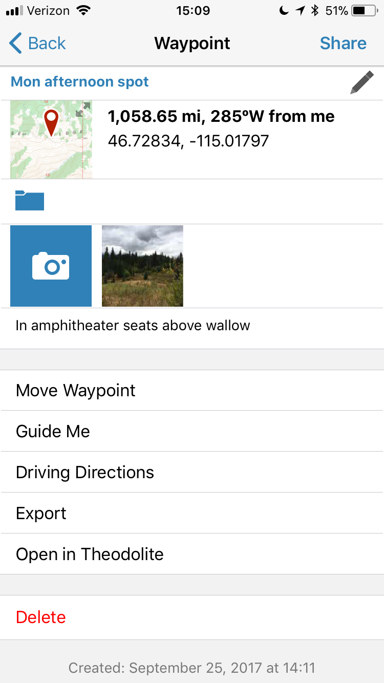
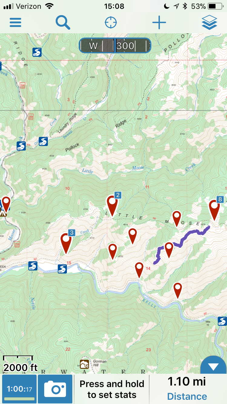
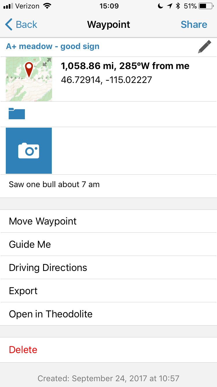
Once you're set up to take advantage of the functionality of the Gaia app I promise that you will be just as happy with its performance as I was. You can see a screen shot in the images below that show how waypoints can be easily added, noted on and even have pictures associated with the waypoint. With the Gaia GPS app, I always knew where I was within ten seconds of firing the app up, and it gave me extreme confidence when I was working myself into new territory during the hunt.
Unless you absolutely require the capability of making a sat call or sending a text via satellite, then there is no need to spend more than $20 on your GPS system if you already own a smartphone. The Gaia GPS app was the most pleasant surprise in my gear bag as far as something far exceeding my performance expectations.
Kyle Zibrowski